| | Section 2 - Southbound Maps from Detroit to the Florida Border 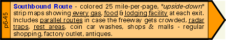 Click here to return to the previous page
As you drive south, you will be able to track your journey on these 25 mile per page colored maps. Milepost-by-milepost and exit-by-exit, you will always know exactly where you are and what services are around you . . . very important in foggy, snowy or other limited visibility conditions. And of course, since "South" is at the top of the page, you will read up the map page - from the bottom to the top - so that everything shown on the right side of the map will be on the right side of your car, and vice versa. It couldn't be easier.
Here's a list of the detail information shown at each exit: - exit number and cross-road name
- every gas, food and lodging service within ½ mile of the exit
- whether the service is on the east (left) or west (right) side of the road
- those facilities which can accommodate large vehicles (eg. RVs) with parking or alongside their pumps
- gas services - a special color indicates whether open 24 hours and/or if they have a mechanic on duty
- gas services - special codes indicate if they also sell diesel fuel, LPG (propane)
- food services - a special color indicates if they have a play area for children, and whether it is inside or outside
- lodging (hotel, motel) services - a special color indicates if they accept pets
- we also indicate those exits with signs indicating police or hospital services
- other exit information includes - tourist centers, pharmacies, superstores (Wal-Mart, etc.), shopping malls, antique malls, 24 hour stores and vet or animal clinics
Drivers love our maps because we show a lot of information about the road ahead. Here's a list of the detail "road" information shown on our maps: - number of traffic lanes and where they merge or expand
- the road speed limit at all locations
- construction zones; where they start and their length, also any lane merges if applicable
- location of all police radar units
- parallel routes and side roads so you know where to get off the interstate (and how to get back on) should the traffic become congested
- those traffic lanes which are "exit only" lanes
The maps include other valuable information such as: - every rest area and welcome center, available facilities and hours of operation ... and how far to the next one!
- major landmarks such as towns, rivers, bridges, railroads
- golf courses and RV campsites
- county lines/names . . . and those counties which are "dry"
Our 25 mile colored maps are so helpful they have won international awards. Don't drive south without them in your car. | | |